Long-range LiDAR
Detection range up to 950 m
Dual mapping cameras
Dual 100 MP RGB camera system
High accuracy
5 mm ranging repeatability
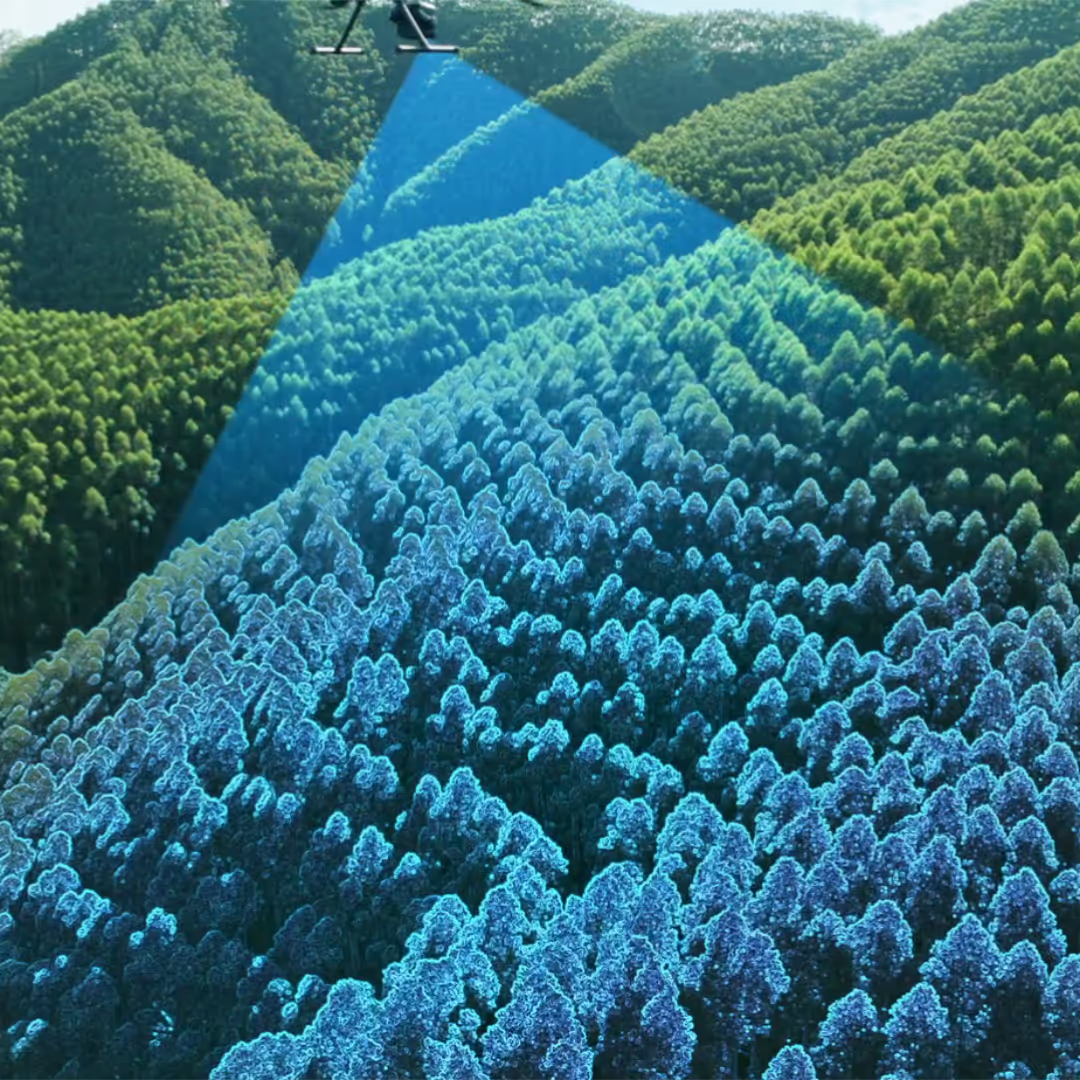
High penetration
Smaller laser spots and higher pulse energy
Large coverage
Cover up to 100 km² per day
End-to-end solution
From data capture to delivery
The L3 offers a maximum detection range of 950 m at 100 kHz, even on 10% reflective surfaces under 100 klx light, with an adjustable pulse rate for optimal performance across diverse missions.
With a 0.25 mrad laser beam, the L3 detects finer details like power lines and branches while delivering stronger penetration and denser ground points for accurate terrain and structure reconstruction.
With a pulse rate of up to 2 million per second and support for 16 returns, the L3 delivers precise spatial reconstruction with adjustable point cloud density and penetration for any mapping scenario.
The DJI Zenmuse L3 offers Linear, Star-Shaped, and Non-Repetitive scan modes for precise mapping, dense vegetation, and complex structure inspections.
With dual 100MP 4/3 CMOS sensors and a mechanical shutter, the L3 delivers higher accuracy and efficiency, with pixel binning enabling 25MP output and rich colour detail even in low light.
Dual RGB mapping cameras offer a wide 107° FOV, capturing data for both DOM and DEM in one flight, even with just 20% LiDAR side overlap, for greater efficiency and coverage.

The upgraded high-precision POS system delivers 0.02° heading and 0.01° pitch accuracy, while the LiDAR achieves 5 mm ranging repeatability with microsecond-level synchronisation and factory-calibration.
The L3 delivers vertical accuracy better than 3 cm at 120 m and 10 cm at 500 m, with point cloud thickness half that of the L2, ideal for detailed analysis and high-accuracy mapping at scales up to 1:500.
With dual 100MP RGB cameras, the L3 achieves a 3 cm GSD at 300 m altitude, with real-time synchronisation enabling precise mapping without GCPs.

With a smaller laser spot and higher pulse energy, the L3 delivers stronger penetration and captures more complete ground data for highly accurate terrain mapping and reconstruction.

When mounted on DJI Matrice 400, L3 delivers outstanding efficiency. At a flight altitude of 300 m, a single flight can cover up to 10 km², enabling up to 100 km² of daily coverage
Simultaneously captures LiDAR and RGB data to generate a range of mapping products from a single flight, including DEM, DOM, and more.

DJI Pilot 2 automates flight setup and previews point cloud results, while Zenmuse L3 enhances Power Line Follow and real-time 3D mapping. With split-screen viewing and instant cloud sync via FlightHub 2, users can monitor, measure, and manage mapping data seamlessly from capture to delivery.
DJI Terra delivers PPK processing for LiDAR and RGB data, ensuring centimetre-level accuracy even without network coverage. Its Gaussian Splatting technology fuses LiDAR and RGB data for highly realistic 3D models, while fusion-based modelling enables simultaneous generation of point clouds, 2D maps, and 3D meshes.
DJI Modify streamlines point cloud processing with intelligent semantic classification that automatically identifies ground, vegetation, buildings, wires, and towers, while Quick and Structure Selection tools refine results with ease. Its Profile tool enables intuitive cross-sectional analysis of terrain and structures, and when paired with L3, it generates comprehensive outputs, including semantic point clouds, DEMs, TINs, point grids, and contour lines, supporting detailed engineering and CAD workflows.

Get in touch with our team today.